Research
- Climate Variability
- Weather types
- North Atlantic Oscilation
- Blocking events
- Storm-tracks
- Cut-off low systems
- Climate extremes
- Vegetation dynamics
- Atmopsheric Rivers
- Nonlinear Analysis
- Natural Hazards
- Datasets
Fires
Wildfires in southern Europe cause frequent extensive economical and ecological losses and, even human casualties, such as the fires in Greece and Italy in 2007 (Amraoui et al., 2012) or in Portugal in 2003 (Trigo et al., 2006). Comparatively to other Mediterranean countries, Portugal is the country with more burnt area and also number of fires per unit area in the last decade (Pereira et al., 2011), mainly during the summer season (Pereira et al., 2005; 2011). According to the fire records available, between 1980 and 2009, wildfires have affected over 3 million hectares in Portugal (JRC, 2011), which corresponds to approximately a third of the Portuguese Continental territory (Figure 1). Furthermore, contrary to other Mediterranean countries (e.g. Spain, Italy, France, Greece), Portugal shows a clear upwards trend for the density of fires (Pereira et al., 2011), with many fires occurring several times over the same region (Figure 2).
Over Portugal the recent years of 2003 and 2005 were particularly outstanding, registering, respectively, total burned areas of 425 726 ha (Trigo et al., 2006) and 338 262 ha (Pereira et al., 2011). However, while the 2003 was triggered by an exceptional heatwave that struck Western Europe (Trigo et al., 2005; 2006), the fire season registered in 2005 was coincident with one of the most severe droughts of the 20th century (Garcia-Herrera et al., 2007; Gouveia et al., 2009). This severe drought had a strong negative impact in vegetation dynamics having delayed significantly the vegetation recovery process that followed (Gouveia et al., 2010; Bastos et al., 2011).
The Climate Change group of Instituto Dom Luíz research activity focuses on fire activity in Mediterranean Europe, with a particular emphasis in Portugal, based on fires detected by remote sensing and registered by the Autoridade Florestal Nacional.
A significant number of studies have addressed the links between fire occurrences and meteorological variables and atmospheric circulation patterns (Pereira et al. 2005; Trigo et al., 2006; Pereira et al. 2011, Amraoui et al., 2012). Additionally the group has been focused on the assessment of landscape components affected by fires and fire hazards (Pereira et al. 2005, Pereira et al. 2011, Bastos et al. 2011; Gouveia et al. 2012). Finally the group collaborates with other IDL groups that focus on mapping fires (Libonati et al. 2010; Libonati et al. 2011);
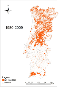 | 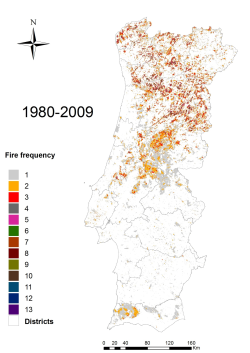 |
Figure 1. Fire scars mapped from 1980 to 2009. | Figure 2 Fire frequency in Portugal from 1980 to 2009. |
References:
- Amraoui M.; Liberato M.R., Calado T.J., DaCamara C.C., Pinto-Coelho L., Trigo R.M. and Gouveia C.M., (2012) "Fire activity over Mediterranean Europe based on information from Meteosat-8". Forest Ecology and Management (in press).
- Bastos A., Gouveia C., DaCamara C.C., Trigo R.M., (2011) “Modelling post-fire vegetation recovery in Portugal”. Biogeosciences, 8, 4559-4601, Copernicus Publications on behalf of the European Geosciences. Union, doi: 10.5194/bgd-8-4559-2011.
- Garcia-Herrera R., Paredes D., Trigo, R.M., Trigo, I.F. Hernández H., Barriopedro D., Mendes M.T. (2007) "The outstanding 2004-2005 drought in the Iberian Peninsula: associated atmospheric circulation", Journal of Hydrometeorology, 8, 483-498.
- Gouveia, C., Trigo, R. M., and DaCamara, C. C. (2009) “Drought and vegetation stress monitoring in Portugal using satellite data”, Nat. Hazards Earth Syst. Sci., 9, 185–195, doi:10.5194/nhess-9-185- 2009.
- Gouveia, C., DaCamara, C. C., and Trigo, R. M. (2010) “Post-fire vegetation recovery in Portugal based on spot/vegetation data”, Nat. Hazards Earth Syst. Sci., 10, 673–684, doi:10.5194/nhess-10- 673-2010.
- Gouveia C.M., Bastos A., Trigo R.M., DaCamara C.C. (2012) "Drought impacts on vegetation in the pre and post-fire events over Iberian Peninsula". Natural Hazards and Earth System Sciences, 12, 3123-3137.
- JRC: Forest Fires in Europe 2009, Report EUR 24502 EN – 2010, JRC-IES / Land Management & Natural Hazards Unit, ISSN 1018-5593, available at: http://effis.jrc.ec.europa.eu/reports/ fire-reports/ (last access: 1 April 2011), 2010
- Libonati, R., DaCamara, C.C., Pereira, J.M.C., and Peres, L.F. (2010) “Retrieving middle infrared reflectance for burned area mapping in tropical environments using MODIS”. Remote Sensing of Environment, 114, 831–843.
- Libonati, R.; DaCamara, C.C. ; Pereira, J.M.C.; Peres, L. F. (2011) “On a new coordinate system for improved discrimination of vegetation and burned areas using MIR/NIR information”. Remote Sensing of Environment, 115, 1464-1477.